All published articles of this journal are available on ScienceDirect.

Agricultural Water Management under Water Scarcity in Algeria: Practices and Future Perspectives
Abstract
Introduction
Algeria is among the countries most severely affected by water scarcity due to its arid and semi-arid climate, irregular rainfall, and high evaporation rates. Agriculture, which consumes over 70% of the nation's freshwater resources, is vital to national food security.
Method
This study evaluates agricultural water management in Algeria by integrating climatic, hydrological, and agricultural data from national institutions to estimate crop water requirements using the FAO CROPWAT 8.0 model.
Results
Results indicate that total water requirements range from 1,423 hm3 in the Oranie–Chott Chergui basin to 3,315 hm3 in the Sahara, with groundwater supplying about 67% of irrigation demand; irrigated areas expanded from 350,000 ha in 2000 to over 1.3 M ha in 2020, while regional disparities persist, especially in southern basins where irrigation efficiency remains below national averages.
Discussion
The findings emphasize the urgent need to improve irrigation efficiency, enhance water productivity, and strengthen coordination among basin institutions, as current trends indicate that without significant efficiency gains, agricultural water demand may exceed 11.3 Bm3 by 2030, intensifying competition for water resources across sectors.
Conclusion
Sustainable water management in Algeria demands the adoption of modern irrigation technologies, the implementation of basin-scale governance, and effective groundwater regulation, as the integration of these strategies is essential to ensure water security and sustain agricultural productivity amid increasing scarcity.
1. INTRODUCTION
Given the highly uneven global distribution of water [1] and the continuous pressures from demographic growth and industrial development, all countries are projected to face significant water scarcity problems in the short term [2]. Water scarcity has become a growing global concern, primarily because global water use increased at more than twice the rate of population growth during the twentieth century [3].
The agricultural sector, as the leading consumer of water resources [4], faces growing pressure from population growth, economic development, and climate change, making it increasingly challenging to ensure food security in the Mediterranean and North African regions [5]. Globally, more than 40% of annual food production comes from irrigated land [6]. As water scarcity intensifies in many parts of the world, prioritizing increased efficiency in agricultural water use is essential for enhancing global food security [7].
Uncertainty about the future availability of water resources for agriculture is increasing. Consequently, it is essential to optimize and reduce water use in agricultural systems while maintaining sustainable levels of production [8, 9].
Algeria ranks among the poorest countries in terms of water resources [10]. Therefore, rational water management is necessary, taking into account the productivity and/or valorization of the water used [8, 11].
This requires a combination of modern irrigation techniques, infrastructure development, research, education, and policy support to ensure the efficient and responsible use of water resources in agriculture [12]. Recently, Algeria has faced various challenges in water resource management due to the rapid growth of domestic, agricultural, and industrial activities [11]. Therefore, agricultural water management requires special attention in Algeria [13].
To address this challenge, it is essential to quantify both water availability and agricultural water demand and to understand how this balance has evolved [14]. Despite numerous studies on water management in Algeria, few have provided a comprehensive national assessment integrating climatic, hydrological, and agricultural data.
This study aims to evaluate agricultural water management in Algeria amid increasing scarcity. This is achieved by analyzing three key components, such as crop water requirements, irrigation efficiency, and water use distribution, across the five main hydrological basins from 2000 to 2020, and by projecting future irrigation water demand up to 2030.
2. MATERIALS AND METHODS
2.1. Study Region
Algeria, the largest country in Africa, extends between latitudes 19° N and 37° N and longitudes 9° W and 12° E, covering an area of approximately 2.38 million km2 [4]. The country displays marked geographical and climatic contrasts that strongly affect water availability and agricultural practices.
2.1.1. Location and Water Resources System
The Total Agricultural Area (TAA) in Algeria covers approximately 42.8 million hectares, which represents 18% of the national territory (238 million hectares). However, the Useful Agricultural Area (UAA) is significantly smaller, measuring only 8.5 million hectares. According to the Ministry of Agriculture and Rural Development (MADR), only about 1.3 million hectares of this area are irrigated, accounting for approximately 15% of the UAA. Furthermore, 3.4 million hectares, or the equivalent of 40% of the UAA, are set to fallow annually. This indicates that Algerian agriculture currently utilizes only a small fraction of the country’s total area.
Crops require water for growth and production. In Algeria, almost all the crops presented in Figs. (1 and 2) are cultivated under rainfed conditions. However, in Southern Algeria, crops are grown exclusively under irrigated conditions, with supplemental irrigation also being utilized for certain crops and vegetables in the Southeast region. Significantly, the area allocated to these crops increased during the 2019-2020 period when compared to the land allocation recorded in 2000-2001.
Out of a total area irrigated in Algeria, 43% of it is irrigated by the traditional method (gravity), 33% by aspersion, and 24% by drip [15]. The rational use of irrigation water is conditioned by mastery of the basic principles of irrigation and by the selection of the most water-saving irrigation systems. As a result, the use of irrigation in all its forms (integral or complementary) is necessary for agricultural production capable of covering the population’s crop requirements.
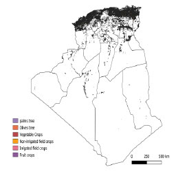
Much of the irrigated land is concentrated in southern Algeria (Fig. 3), where many crops require irrigation. Irrigation is also common in the eastern and southeastern parts of Algeria, particularly in the areas observed in this study. The primary aquifers that supply water to Algeria include the Continental Intercalary (CI), the Terminal Complex, the CI (Albian) aquifer, and local systems supplying regions such as Biskra, El-Oued, Khenchela, and O.E. Bouaghi.
Fruit crops were the leading irrigated crops, accounting for 473 thousand hectares. Vegetable crops accounted for the second-most irrigated acreage, with more than 406 thousand hectares harvested. Biskra had the most irrigated land among all wilayas in Algeria, with 117 thousand hectares of irrigated cropland, accounting for 8,5 percent of all irrigated cropland in Algeria. El-Oued ranked second, with 98 thousand hectares, or 7,1 percent of all Algeria irrigated cropland; O.E.Bouaghi, Khenchela, and Adrar rounded out the top 5 wilaya in total irrigated cropland acreage. The five highest-ranked wilayas by irrigated acreage accounted for about 30 per cent of all irrigated land in Algeria.
The available water potential in Algeria is estimated at 19.4 billion m3/year [16], divided as follows: In the North, 14,2 billion m3/year including 11,2 billion in surface runoff and 3 billion in underground resources (non-renewable). 5 billion m3/year in the Saharan regions (South), 0.2 billion in surface runoff and 5 billion in non-renewable underground resources. During dry periods, the National Water Plan (PNE) estimates that conventional surface water potential may decline by 30–40% compared to the average period. Groundwater abstraction, particularly in arid and Saharan regions, may reach a maximum withdrawal rate of about 2.3 billion m3 per year.
According to the PNE 2017 Table 1, Algeria’s annual renewable water resources are estimated at just 6.2 billion m3. Surface resources available from 75 operational dams are assessed at 3.2 billion m3/year, with a storage capacity of around 8.1 billion m3. The volume of groundwater resources currently exploited is estimated at 6.4 billion m3/year, three billion m3/year of renewable resources, and 3.4 billion m3/year of non-renewable resources.
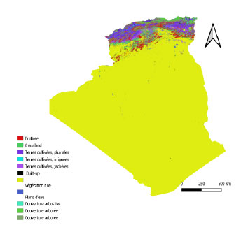
Land cover of crops in Algeria.
Land cover categories.
Irrigated crop areas in Algeria.
| Water potential Billion m3/year | |||||
|---|---|---|---|---|---|
| Average period | Dry period | Remark | |||
| Water resources | Superficial | Underground | Superficial | Underground | |
| Renewable | 11,4 | 3 | 6,8 | 1,8 | 95% located in the north |
| 14,4 | 8,6 | ||||
| Non-renewable | 0 | 5 | 0 | 2,3 | 100% located in the south |
| 5 | 2,3 | ||||
| Total | 19,4 | 10,9 | |||
2.2. Data Resource
This study covers the period 2000–2020 and integrates data from both administrative (wilaya-level) and hydrological (basin-level) scales. Information on Water Resources Availability (WRA), total Water Use (WU), Agricultural Water Use (AWU), and Irrigation Efficiency (IE) was collected from the 48 wilayas of Algeria and aggregated across the country’s five main hydrological ba- sins: Oranie–Chott Chergui, Cheliff–Zahrez, Algérois–Ho-dna–Soummam, Constantinois–Seybouse–Mellegue, and Sahara.
Data on irrigated agricultural land, Arable Land (A), and Sown Area (As) were obtained from the Statistical Series B published by the MADR [15].
The growth periods of irrigated crops were derived from the cultivation calendars of the National Institute of Agricultural Extension (INVA), while meteorological inputs required for the FAO CROPWAT 8.0 model, including maximum and minimum temperature, relative humidity, wind speed, sunshine duration, and precipitation, were provided by the National Office of Meteorology (ONM).
2.2.1. Data and Projection Procedure
This study integrates climatic datasets, agricultural statistics, and hydrological data, encompassing both a reference period and a projection dataset for future conditions.
The crop-specific information used in this study includes key parameters such as sowing and harvesting dates, obtained from the National Institute of Agronomic Valorization (INVA), as well as cultivated areas (in hectares) reported in the Series B 2019 agricultural statistics published by the Algerian MADR [17].
The climatic variables include monthly averages of precipitation, maximum and minimum air temperatures, wind speed, solar radiation, and relative humidity, derived from the ONM network of meteorological stations covering all 48 wilayas of Algeria.
The 2030 projections were established by combining datasets from MADR and PNE. Future irrigation demand was estimated through trend extrapolation of irrigated areas and adjustments in irrigation efficiency by basin. Additional estimates of domestic and industrial water use were integrated to assess the overall national water demand under projected conditions.
2.3. Calculating Crop Water Requirement
The Crop Water Requirements (CWR) of agricultural production are determined using a bottom-up accounting system. The water factor (CWR) of agricultural output is calculated as the sum of the blue and green water components for each irrigated crop. Where CWR denotes the overall water footprint of local agricultural production in Algeria (m3/year), CWRi denotes the water footprint of each crop type grown there.
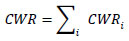
CWR refers to the volume of water resources allocated for crop production (including all primary crop outputs) within a region. It is composed of blue water, representing conventional water resources (CWRblue), and green water, corresponding to rainwater resources (CWRgreen), as in (2-3):


Where A is the area of the irrigated crop in hm2; haand crop evapotranspiration (ETc) in mm.
By using crop variables and reference evaporation, ETc was computed (4). According to the following relationship, reference evaporation (ET0) was calculated using the most recent revision of the F.A.O. Penman-Monteith (Allen et al., 1998) (5).
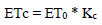
Where ETc is crop evapotranspiration (mm), ET is reference evapotranspiration (mm), and Kc is the crop coefficient.
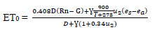
Where D is the slope of the saturation vapor pressure function (kPa/°C); Rn is the net radiation at the crop surface; G represents the soil heat flux density (MJ/m2/day); is the psychometric constant (kPa/°C); T refers to mean daily air temperature at 2 m height (°C); u2 is the wind speed (m/s); es is the vapor pressure of the air at saturation (kPa); and ea is the actual vapor pressure (kPa).
In estimating crop evapotranspiration (ETc) with the CROPWAT model, the durations of crop growth stages, crop coefficients (Kc), allowable soil-moisture depletion (P), and yield response factors (Ky) were adjusted to reflect the conditions of the study area. These parameters were defined according to the FAO database and previous studies [18] [19].
Calculating CWRblue is essential for irrigation planning and sustainable water management in agriculture. It involves determining a crop's specific water needs by considering factors such as crop type, growth stage, local climate, and soil characteristics. Farmers and irrigation planners use this information to determine when and how much external water (blue water) should be applied to the crops to meet their water requirements and optimize agricultural yields.
The concept of CWRblue is often used in conjunction with CWRgreen (green water requirement), which represents the portion of a crop's water needs that can be met by natural rainfall and soil moisture. Together, CWRblue and CWRgreen provide a comprehensive picture of a crop's total water requirement and help guide irrigation practices to ensure efficient water use in agriculture.
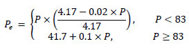
CWRgreen is defined as the yearly portion of precipitation effectively contributing to water availability on cultivated land (6):
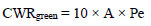
In this equation, A is the size of irrigated land within the region, expressed in hectares × 102 (hm2), and Pe is the annual adequate precipitation in millimeters. The latter was calculated according to the methodology proposed by the FAO CROPWAT model [20], as outlined below (7):
CWRblue, which is equivalent to the actual planted area (hm2) times the annual irrigation allotment (m3, hm2), is mostly represented by the blue WF of agricultural output (8). The irrigation quota at this location varies depending on crop type and annual rainfall, which are entirely determined by the actual conditions of crop planting in Algeria.
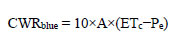
Crop evapotranspiration (ETc) is measured in millimeters (mm); effective precipitation (Peff) is measured in millimeters (mm); plant area (A) is measured in square meters (hm2); and Water Depth (WD) is converted to cubic meters of water per acre (m3, hm2) by multiplying it by ten.
3. RESULTS
3.1. Water Requirement of Different Crops
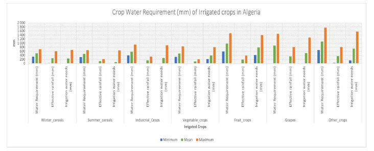
A range of typical water usage for irrigated crops in Algeria is shown in Fig (4) (Appendix). The graphs illustrate how much water is required for irrigation to grow various crops, showing that some, such as fruit crops and summer cereals, can require 600 mm or more. Other plants, such as winter cereals, vegetable crops, and industrial crops, only need 400 to 500 mm of water. When plants are located in a cooler, humid region, evaporation rates are lower and crop water consumption is lower than in a hot, dry climate.
In Algeria, the Total water requirement for winter cereals is 1.4 billion m3, with 517 million m3 of adequate rainfall, or 3 percent of all irrigated winter cereals areas, and 857 million m3 of water requirement, accounting for 97 percent of all irrigated winter cereals in Algeria.
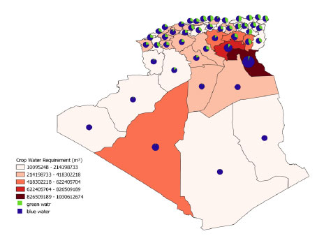
The total water requirement of irrigated crops in Algeria (Fig. 5) and Table 2 is 10.3 billion m3. Fruit crops accounted for more than 45 percent of Algeria's total crop water requirement. Vegetable crops accounted for almost 19 percent of total crop water requirements and 13 percent of crop water requirements in Algeria, predominantly for winter cereals.
Crop water requirement (mm) of irrigated crops in Algeria.
| Crop | Irrigated Area (ha) | Water Requirement (mm) | Effective Rainfall (mm) | Irrigation Water Requirement (mm) | Total Water Requirement (m3) | Total Effective Rainfall (m3) | Total Irrigation Water Requirement (m3) |
|---|---|---|---|---|---|---|---|
| Fruit crops | 473 415 | 46 658 | 8 679 | 37 978 | 4 797 135 368 | 716 369 494 | 4 080 765 874 |
| Vegetable crops | 406 565 | 23 460 | 4 598 | 18 863 | 2 042 783 904 | 375 021 807 | 1 667 762 097 |
| Other cops | 171 643 | 49 537 | 17 170 | 32 367 | 1 784 514 427 | 506 005 388 | 1 278 509 039 |
| Winter_cereals | 276 495 | 12 517 | 11 269 | 23 785 | 1 374 704 474 | 517 521 450 | 857 183 522 |
| Industrial Crops | 36 749 | 17 536 | 4 553 | 12 984 | 207 280 588 | 69 579 619 | 137 700 969 |
| Grapes | 15 285 | 40 347 | 15 935 | 24 412 | 126 174 059 | 72 071 679 | 54 102 380 |
| Summer_cereals | 1 746 | 3 713 | 917 | 2 796 | 10 132 082 | 650 886 | 9 481 196 |
| Total | 1 381 898 | 193 768 | 63 121 | 153 185 | 10 342 724 902 | 2 257 220 323 | 8 085 505 077 |
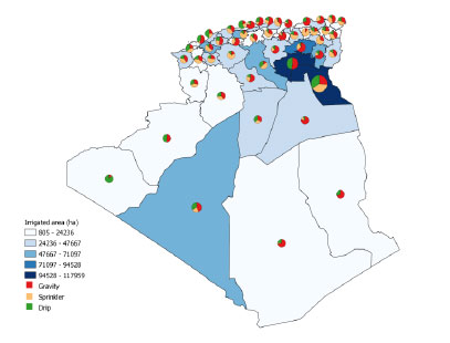
Irrigated area in ha and irrigation system of irrigated crops.
Vines accounted for approximately 4% of the total crop water requirement in Algeria, and Industrial crops utilized about 2%, with most of this demand supplied by surface-water sources for thermoelectric power generation. Summer cereals and other crops accounted for the largest share, at 17% of total crop water demand.
Ten wilaya (El-oued, Biskra, Adrar, Batna, Khenchela, Msila, Mascara, Setif, Ouargla, and Djelfa) account for more than half of Algeria's total crop water requirement. El-oued accounted for almost 10 percent of the total water requirement (CWR) for crops and 7 percent in Biskra. Moreover, Adrar and Batna accounted for 12% of Algeria's crop water requirements.
3.2. Water Footprint of Production
The total (green and blue) water footprint of crop production (Fig. 6) is dominated by fruit and vegetable crops, which together account for 66% of the water footprint. The blue water footprint of irrigated crops is dominated by fruit crops, which account for almost 50% of the total green water footprint, followed by vegetable crops with a share of about 21%, winter cereals with 11%, and all other crops with about 15%. In the case of the green water footprint, three crop types, fruit crops (31.7%), winter cereals (22.2%), and vegetable crops (16.6%), account for a combined share of 70% or more. All other crops collectively account for the remaining 30% of the total green water footprint.
The adequate rainfall for irrigated crops (Fig. 7) varies greatly across wilayas, ranging from 10% at Khenchela (71,052 ha irrigated) to 0.2% at Constantine (2,175 ha irrigated). The effective rainfall percentage varies significantly in the south, ranging from 0.01% at Tindouf (805 ha irrigated) to 4% at Biskra (117,959 ha). The south has the least adequate rainfall, whereas the east has the highest.
The highest irrigation intensity in the irrigated crop (Fig. 8) occurs in the southeast of Algeria. The irrigation intensity in these areas is above 85%, and in some wilayas it exceeds 98%. Arid and semi-arid regions in Algeria cannot raise crops without irrigation. Large parts of the west and south wilayas have an average irrigation intensity of 70-85%. Some wilaya from the north and east have a low intensity of irrigation, varying from 15 to 30%.
Approximately 52% of the crop water requirement is irrigated through groundwater resources. Only 26% of agriculture's water demand is fulfilled by surface water resources, and the remaining 22% of crop water needs are covered by adequate rainfall.
3.3. Regional Distribution of Agricultural Water Demand
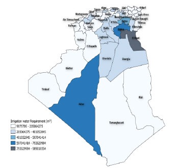
Significant spatial disparities exist among Algeria’s five main hydrological basins. Total Water Requirements (TWR) Table 3 range from 1,423 hm3 in the Oranie–Chott Chergui basin to 3,315 hm3 in the Sahara. A strong correlation between irrigated area and total water demand indicates that expansion of irrigated land is the primary driver of increasing demand. The Sahara accounts for 35% of total agricultural water demand, followed by Constantinois–Seybouse–Mellegue (21.7%), Algérois–Hodna–Soummam (20.3%), and Cheliff–Zahrez (18.1%). Despite significant irrigation in southern areas, their contribution to food security remains limited, indicating inefficiencies in water allocation.
3.4. Dependence on Irrigation and Rainfall Contribution
Analysis of adequate rainfall relative to total water requirements shows pronounced regional contrasts Table 3. Rainfall contribution ranges from 5.1% in the Sahara to 39.7% in the Constantinois basin, implying that irrigation supplies 60–95% of crop water needs. The Constantinois–Seybouse–Mellegue basin, characterized by a Mediterranean climate and a dense dam network, demonstrates high hydrological resilience, whereas the Sahara relies almost entirely on non-renewable groundwater resources.
Percentage contributions of green and blue water to the total virtual water consumed by all studied crops in Algeria.
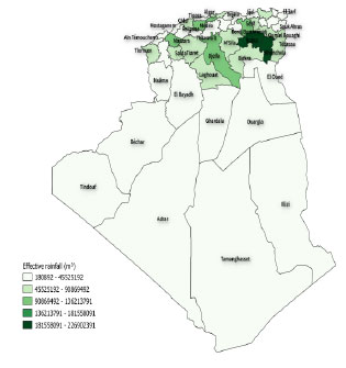
Effective rainfall in m3 of irrigated crops in Algeria.
|
Water shade |
Irrigated Area (ha) | Total Water Requirement (hm3) | Total Effective Rainfall (hm3) | Total Irrigation Water Requirement (hm3) | Surface Water (hm3) | Groundwater (hm3) |
|---|---|---|---|---|---|---|
| Oranie, Chott Chergui | 217 880 | 1 423 | 332 | 1 090 | 374 | 716 |
| Cheliff, Zahrez | 235 775 | 1 679 | 408 | 1 270 | 701 | 569 |
| Algérois, Hodna, Soummam | 249 999 | 1 895 | 542 | 1 353 | 546 | 807 |
| Constantinois, Seybouse, Mellegue | 309 927 | 2 032 | 807 | 1 225 | 1 072 | 153 |
| Sahara | 368 317 | 3 315 | 168 | 3 147 | 0 | 3 147 |
| Total | 1 381 898 | 10 343 | 2 257 | 8 086 | 2 693 | 5 393 |
Intensity of irrigation in m3 per wilaya of irrigated crops.
3.5. Surface and Groundwater Contributions
The relative contribution of surface and groundwater to irrigation varies widely among basins Table 3. The Constantinois–Seybouse–Mellegue basin relies mainly on surface water (87.5%), while the Sahara depends exclusively on groundwater. In northern basins such as Oranie, Cheliff, and Algérois, groundwater use ranges from 55–65%, compensating for limited reservoir storage. This growing dependence on aquifers highlights overexploitation risks already identified in the National Water Plan (PNE, 2017) and AGIRE.
3.6. Spatial Patterns and Efficiency Gaps
The spatial pattern of total water requirements follows a north–south gradient Table 3, with southern basins showing the highest demands and lowest rainfall. Although irrigation infrastructure has improved, efficiency gains have not kept pace with the expansion of irrigated areas. Consequently, water consumption continues to rise, exacerbating groundwater depletion and regional water stress.
3.7. National Water Balance and Future Projections
Algeria’s water resources remain scarce in relation to national demand, with estimates indicating an annual availability of about 10.25 billion m3, while total consumption is projected to reach nearly 11.35 billion m3 per year, varying across basins.
As a result, the water balance shows a deficit of approximately 1.1 billion m3 per year Table 4 and Table 5, with variations observed across different basins. By 2030, the total available water resources are projected to reach around 16.1 billion m3, of which irrigation is expected to account for about 73%, domestic consumption for 26%, and industrial activities for roughly 1%.
On average, irrigated areas are primarily supplied by groundwater, which accounts for approximately 75% of the required volume, while surface water contributes the remaining 25%. The deficit will be 2.4 billion with available resources of 13.7 billion, and the total amount requested will be 16.1 billion.
4. DISCUSSION
4.1. Drivers of Water Demand
The results confirm that the expansion of irrigated areas is the principal driver of agricultural water demand in Algeria. This finding is consistent with regional studies [21, 22], which demonstrate that irrigation demand increases exponentially with cultivated area, even under relatively stable climatic conditions. The strong correlation between irrigated surface area and total water requirement underscores Algeria’s structural dependence on water-intensive agricultural production systems.
| Resource type | Volume Mobilized | |||
|---|---|---|---|---|
| Current state | Projections 2030 | |||
| Volume produced | Number of infrastructure | Volume produced | Number of infrastructure | |
| Surface water | 3.2 | 75 dams | 4.4 | 120 dams |
| Underground water | 6.4 | Renewable resources 3 Bm3 Non-renewable resources: 3.4 Bm3 |
8 | Renewable resources 3 Bm3 Non-renewable resources: 5 Bm3 |
| Water Desalination | 0.6 | 10 | 0.91 | |
| Water Purification | 0.05 | 177 | 0.35 | |
| Total | 10.25 | 13.7 | ||
| Needs | Volume requested | |||
| Drinking water supply | 3.1 | 4.1 | ||
| Industry | 0.15 | 0.2 | ||
| Irrigation | 8.1 | 11.8 | ||
| Total | 11.35 | 16.1 | ||
|
Volume requested Bm3/year |
||
|---|---|---|
| Current state | Projections 2030 | |
| Drinking water supply | 3.1 | 4.1 |
| Industry | 0.15 | 0.2 |
| Irrigation | 8.1 | 11.8 |
| Total | 11.35 | 16.1 |
4.2. Hydrological Dependence and Sustainability Risks
The heavy reliance on groundwater abstraction, particularly in the southern and semi-arid regions, reflects an unsustainable trajectory of resource exploitation. Continuous withdrawals from the Continental Intercalaire and Continental Terminal aquifers are depleting nonrenewable reserves, threatening the long-term viability of agricultural systems in the Sahara. Without effective management, this overexploitation may accelerate salinization, aquifer drawdown, and declining irrigation efficiency, as also reported in recent hydrological assessments [16, 23].
4.3. Regional Inequalities and Food Security
Although southern regions consume the most significant proportion of irrigation water, their contribution to national food production remains limited, indicating inefficient resource allocation. In contrast, northern basins, where rainfall is more abundant and infrastructure is denser, show higher productivity per cubic meter of water. These disparities highlight the need for regional redistribution of water investments and for promoting efficiency-oriented agricultural planning to strengthen food security at the national level.
4.4. Toward Efficiency-Oriented Water Management
A transition from a supply-driven model to demand-based management is essential for ensuring long-term sustainability. Policy priorities should focus on:
(1) Crop diversification toward low-water-demand species such as sorghum, barley, and forage shrubs.
(2) Reuse of treated wastewater for non-food agricultural production.
(3) Artificial recharge of aquifers and systematic monitoring of piezometric levels.
(4) Widespread adoption of localized irrigation systems (drip and sprinkler).
(5) Integrated basin-level governance to guarantee equitable water allocation among agricultural, domestic, and industrial sectors.
These strategies are consistent with the FAO Water Scarcity Initiative, which emphasizes enhancing water productivity (m3 kg−1), conserving groundwater resources, and maintaining food security under increasing climatic stress.
5. STUDY LIMITATIONS
This study relies on official secondary datasets (MADR, ONM, PNE) that may include data uncertainties. The CROPWAT 8.0 model uses generalized parameters (Kc, Ky) that may not fully reflect local climatic variability. Assuming constant irrigation efficiency over time may not reflect actual conditions. Future work should incorporate field validation, higher-resolution data, and economic modeling of irrigation efficiency improvements.
CONCLUSION
This study aimed to evaluate Algeria’s agricultural water management under conditions of growing scarcity by quantifying water availability, irrigation demand, and regional disparities over the 2000–2020 period. The results reveal a persistent imbalance between renewable water resources and irrigation requirements, largely driven by the rapid expansion of irrigated land. The irrigated area increased from about 350,000 ha in 2000 to nearly 1.38 million ha in 2020, with approximately two-thirds of the area dependent on groundwater. This trend highlights the sector’s structural dependence on non-renewable water sources and the urgent need for sustainability-oriented management.
Although modernization efforts have introduced sprinkler and drip systems, traditional surface irrigation still accounts for nearly half of the irrigated area, operating at efficiencies below 60%. As a result, irrigation consumes nearly 71% of Algeria’s total available water. If current trajectories continue, irrigation demand could reach 11.8 billion m3 yr−1 by 2030, exceeding sustainable limits and threatening both aquifer reserves and national food security.
To achieve the objectives of sustainable agricultural production and efficient water use, Algeria must prioritize a transition to integrated basin-scale water resources management. Key strategies include:
Expanding localized irrigation (drip and sprinkler) and rehabilitating obsolete infrastructure.
Promoting crop selection adapted to regional water availability (e.g., cereals, forages, and drought-tolerant species in arid zones).
Encouraging treated wastewater reuse and artificial recharge of aquifers.
Strengthening data monitoring and governance mechanisms linking agricultural, hydrological, and climatic sectors.
By adopting these measures, Algeria can increase the productivity of each cubic meter of water while safeguarding its limited reserves. In the broader context of arid and semi-arid countries, this research underscores that sustainable water management in agriculture is not solely a technical challenge but also a strategic policy priority essential for food and water security.
AUTHORS' CONTRIBUTIONS
The authors confirm contribution to the paper as follows: H.M.: Conceptualized the study, collected data, performed analysis, and wrote the manuscript; D.H. and R.D.: Contributed to data interpretation, methodological validation, and manuscript review. All the authors reviewed the results and approved the final version of the manuscript.
LIST OF ABBREVIATIONS
| AWU | =Agricultural Water Use |
| CWR | =Crop Water Requirement |
| ET0 | =Reference Evapotranspiration |
| ETc | =Crop Evapotranspiration |
| FAO | =Food and Agriculture Organization |
| IE | =Irrigation Efficiency |
| Kc | =Crop Coefficient |
| MADR | =Ministry of Agriculture and Rural Development |
| PNE | =Plan National de l’Eau |
| TWR | =Total Water Requirement |
| UAA | =Useful Agricultural Area |
| WRA | =Water Resources Availability |
| WF | =Water Footprint |
AVAILABILITY OF DATA AND MATERIALS
All the data and supporting information are provided within the article.
ACKNOWLEDGEMENTS
The authors express their gratitude to the Ministry of Agriculture and Rural Development (MADR), the National Water Plan (PNE), the Water Basin Agency (ABH – Agence des Bassins Hydraugraphiques), and the FAO Land and Water Division for providing access to agricultural and hydrological data used in this research.
APPENDIX: EXPLANATION FOR FIGURE 4
Crop water requirement (mm) of Fruit crops in Algeria.
Crop water requirement (mm) of Grapes in Algeria.
Crop water requirement (mm) of industrial crops in Algeria.
Crop water requirement (mm) of other crops in Algeria.
Crop water requirement (mm) of summer cereals in Algeria.
Crop water requirement (mm) of vegetable crops in Algeria.
Crop water requirement (mm) of winter cereals in Algeria.